• Skip to secondary menu
  • Skip to main content
  • Skip to footer
  • Home
    • About Baburek.co
    • Privacy
    • Terms
    • Banners
      • Baburek Banners
      • Design Studio Banners
    • little Design Studio
  • Shop

baburek.co

  • Facebook
  • Instagram
  • Pinterest
  • Twitter
  • YouTube
  • Outdoors
    • Camping
    • Hiking
  • Magazine
    • Mag : Caribbean
    • Mag: Europe
    • Mag: North America
    • Food
    • World
  • Images
    • Cover Image
    • Caribbean
    • Europe
    • North America
      • Images of Canada
      • Images of USA
    • Flora and Fauna
  • Video
    • Caribbean
    • Europe
    • North America
  • Maps
    • Africa
    • Asia
    • Australia & Oceania
    • Europe
    • Middle East
    • North America
    • Central America
    • Caribbean
    • South America
    • Antarctica
    • Arctic
  • Countries
    • Africa
      • North Africa
      • East Africa
      • Central Africa
      • West Africa
      • Southern Africa
    • Asia
      • North & West Asia
      • Southeast Asia
    • Australia and Oceania
    • Europe
      • North Europe
      • East Europe
      • Central Europe
      • West Europe
      • South Europe
    • Middle East
    • North America
    • Central America
    • Caribbean
    • South America
    • Arctic
    • Antarctica
    • Oceans
  • microBlog
    • Books
    • Design & Tech
      • Web
    • Hands-on
You are here: Home / Maps / Maps Middle East / Map of Middle East

Map of Middle East

January 21, 2009 by Baburek

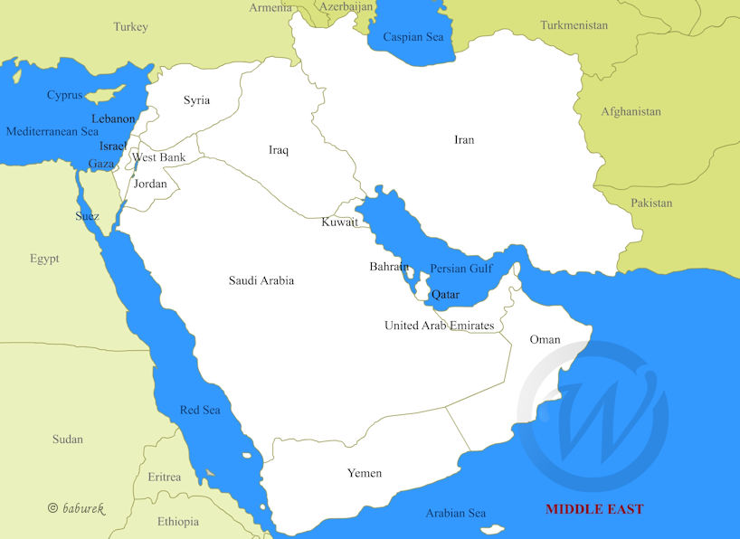
The term Middle East refers to a region in western Asia located mostly on Arabian Peninsula but often includes surrounding neighbors like Iran, Egypt and its Sinai Peninsula (map), Turkey (map) and even more near by to the region countries.

Discover Middle East…

Countries of Middle East on the Map

Map of Middle East
Map of Middle East

Costlines of Middle Eastern countries are stretched along Arabian Sea, Persian Gulf, Gulf of Aden, Red Sea, Gulf of Aqaba, Mediterranean Sea and the Caspian Sea.

Gulf of Aqaba is located in northern part of Red Sea, squeezed in between Egypt’s Sinai Peninsula and on the opposite side by the Arabian Peninsula.

Countries of Middle East on Maps

  • Bahrain
  • Iran
  • Iraq
  • Israel
  • Jordan
  • Kuwait
  • Lebanon
  • Oman
  • Qatar
  • Palestinian Territories
  • Saudi Arabia
  • Syria
  • United Arab Emirates
  • Yemen

Last updated…

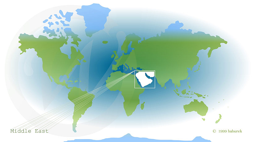
Middle East on the World Map

Middle East on the Map of the World

In the neighborhood

East – Map of Asia…

Southwest – Map of Africa…

Northwest – Map of Europe…

Geographical Maps…

Share this:

  • Click to share on WhatsApp (Opens in new window) WhatsApp
  • Click to email a link to a friend (Opens in new window) Email
  • Click to share on Facebook (Opens in new window) Facebook
  • Click to share on LinkedIn (Opens in new window) LinkedIn
  • Click to share on Reddit (Opens in new window) Reddit
  • Click to share on Pinterest (Opens in new window) Pinterest

Filed Under: Maps Middle East Tagged With: Arabian Peninsula, Bahrain, Dead Sea, Indian Ocean, Iran, Iraq, Israel, Jordan, Kuwait, Lebanon, Middle East, Near East, Oman, Palestinian territories, Persian Gulf, Qatar, Read Sea, Saudi Arabia, Syria, United Arab Emirates, Yemen

Footer

Baburek.co

  • Home
  • Outdoors
    • Camping
    • Hiking
  • Magazine
  • Images
  • Videos
    • Caribbean
    • Europe
    • North America
  • Maps
  • Countries

Recently Published

  • Never Again Vacation Destination
  • 16:9 Aspect Ratio Maps
  • New Year’s Fireworks!
  • Joyeux Noël / Merry Christmas
  • Food for Our Thoughts
  • Video – October on Mont Royal
  • Autumn in Montreal
  • Pumpkin Carving Ideas for Halloween

About

  • Home
  • About Baburek.co
    • Banners
      • Baburek Banners
      • Design Studio Banners
    • Privacy
    • Terms
  • little Design Studio @ baburek.co
  • Online Shop...

Log in © 2025 · Baburek.co, All Rights Reserved