Hike to Lac à l’Ours
If your are staying at Lac Chat campground, or you just came to spend a day at Parc national du Mont Tremblant and had decided to park a car at Lac Chat (panoramic video scene) hiking my be one of the outdoor activates you may enjoy.
On the opposite side from the campground and the lake, on the Road 1 you’ll find the larger trail heading for the surrounding hills.
Once you hit the trail soon after it will become narrower even though wide enough and well maintained throughout the climb. The terrain itself is not difficult to climb even for the youngest among us (6). Directions are well placed along the trail and on the intersections.

Season: Autumn
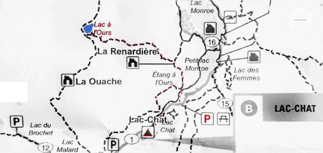
Location: Parc national du Mont Tremblant, Quebec (map)
Hiking: 4-5 km or around 2h from Lac Chat to Lac à l’Ours (4h in total)
Elevation: estimated at 565 meters or 1854 feet
Photo gallery – Hiking to Lac à l’Ours
In the month of October Laurentian forest is bursting with fall colors.


Lac Chat – Panoramic Autumn video scene…
It seams at times that creeks and streams are ever present on one or another side of the hiking path. Along the route there’s another lake you’ll come across. The Laurentian region (discover) is covered in the mixed forest, deciduous–evergreen forest where rich Autumn colors in the month of October stand out among everlasting greens.
Detail from a map
– extracted from the larger area map that is provided to visitors by Sépaq [+] at the park entrance
– hiking trail on the map
More Hiking Trails…
Glamping at Lac Chat…
Intro photo of Lac à l’Ours – Parc national du Mont Tremblant…
More Images featuring Canada…