• Skip to secondary menu
  • Skip to main content
  • Skip to footer
  • Home
    • About Baburek.co
    • Privacy
    • Terms
    • Banners
      • Baburek Banners
      • Design Studio Banners
    • little Design Studio
  • Shop

baburek.co

  • Facebook
  • Instagram
  • Pinterest
  • Twitter
  • YouTube
  • Outdoors
    • Camping
    • Hiking
  • Magazine
    • Mag : Caribbean
    • Mag: Europe
    • Mag: North America
    • Food
    • World
  • Images
    • Cover Image
    • Caribbean
    • Europe
    • North America
      • Images of Canada
      • Images of USA
    • Flora and Fauna
  • Video
    • Caribbean
    • Europe
    • North America
  • Maps
    • Africa
    • Asia
    • Australia & Oceania
    • Europe
    • Middle East
    • North America
    • Central America
    • Caribbean
    • South America
    • Antarctica
    • Arctic
  • Countries
    • Africa
      • North Africa
      • East Africa
      • Central Africa
      • West Africa
      • Southern Africa
    • Asia
      • North & West Asia
      • Southeast Asia
    • Australia and Oceania
    • Europe
      • North Europe
      • East Europe
      • Central Europe
      • West Europe
      • South Europe
    • Middle East
    • North America
    • Central America
    • Caribbean
    • South America
    • Arctic
    • Antarctica
    • Oceans
  • microBlog
    • Books
    • Design & Tech
      • Web
    • Hands-on
You are here: Home / Maps / Maps North America / Map of the United States

Map of the United States

January 18, 2009 by Baburek

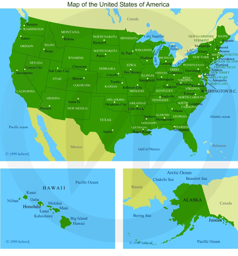
United States of America is bordering with Canada (map) on the North, from the East coast to the West coast and along the State of Alaska in full length of 5,524 mi. or 8,891 km.

On the South U.S.A borders in its full length, 1,954 mi. or 3,145 km. with the country of Mexico (map).

Discover United States of America…

US on the Map

Map of the United States of America

United States of America consists of 50 states, two noncontiguous states and forty-eight that are bounded by the Atlantic Ocean on the East coast, Gulf of Mexico on the South and on the West by the Pacific Ocean.

The two noncontiguous states

  • State of Alaska (map) is located on the north of the North American continent and it’s tucked in its north-west corner, next to Canadian territory of Yukon, province of British Columbia, and it’s surrounded by waters of the Gulf of Alaska, Bering Sea – part of the Pacific Ocean, Beaufort Sea – part of the Arctic Ocean.
  • Island State of Hawaii (map) is located in the Pacific Ocean, around 2,000 mi or 3,218 km to the west from the mainland United States.

Last updated…

Map of North America…

Videos featuring USA…

USA Image Gallery…

Share this:

  • Click to share on WhatsApp (Opens in new window) WhatsApp
  • Click to email a link to a friend (Opens in new window) Email
  • Click to share on Facebook (Opens in new window) Facebook
  • Click to share on LinkedIn (Opens in new window) LinkedIn
  • Click to share on Reddit (Opens in new window) Reddit
  • Click to share on Pinterest (Opens in new window) Pinterest

Filed Under: Maps North America Tagged With: Alabama, Arctic, Atlantic, California, Caribbean Sea, Florida, Gulf of Mexico, Montana, New York, Pacific, Texas, United States, USA, Vermont, Washington

Footer

Baburek.co

  • Home
  • Outdoors
    • Camping
    • Hiking
  • Magazine
  • Images
  • Videos
    • Caribbean
    • Europe
    • North America
  • Maps
  • Countries

Recently Published

  • Videos – Cottontail rabbit
  • Never Again Vacation Destination
  • 16:9 Aspect Ratio Maps
  • New Year’s Fireworks!
  • Joyeux Noël / Merry Christmas
  • Food for Our Thoughts
  • Video – October on Mont Royal
  • Autumn in Montreal

About

  • Home
  • About Baburek.co
    • Banners
      • Baburek Banners
      • Design Studio Banners
    • Privacy
    • Terms
  • little Design Studio @ baburek.co
  • Online Shop...

Log in © 2025 · Baburek.co, All Rights Reserved